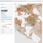
 In the Southern California Crime Study (SCCS), we made an effort to contact each police agency in the Southern California region and request address-level incident crime data for the years 2005-2012. Many of the agencies were willing to share their data with us. As a consequence, we have crime data for 2,740 of the 3,852 tracts in the region, which cover 219 of the 341 cities and 83.3% of the region’s population.
Further information
The data come from crime reports officially coded and reported by the police departments. We classified crime events into 6 Uniform Crime Report (UCR) categories: homicide, aggravated assault, robbery, burglary, motor vehicle theft, and larceny. Crime events were geocoded for each city separately to latitude–longitude point locations using ArcGIS 10.2, and aggregated to various units such as blocks, block groups, and census tracts. The average geocoding match rate was 97.2% across the cities, with the lowest value at 91.4%. These data have been used in prior studies (see below).
In 2010:
- Of 270,095 blocks, we have crime data for 208,091 (77.04%)
- We have crime data covering population of 16,779,884 out of 20,149,002 total (83.28%)
- 128,125 blocks have crime data in all years covering 11,122,770 population (55.2% of total population)
- 150,341 blocks have crime data in all years but one, covering 12,442,179 population (61.75% of total population)